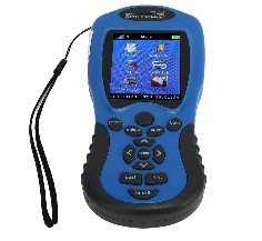
A GPS Land Measuring Meter is a tool used for measuring land area, distances, and locations using GPS technology. It combines traditional measuring tools with advanced satellite-based navigation to provide accurate and efficient land measurement. Below are the key features of a GPS Land Measuring Meter:
1. GPS-Based Measurement:
- Accurate Location Data: Uses Global Positioning System (GPS) to determine the precise location and distances of points on the land being measured.
- High Precision: Typically provides measurements with a high degree of accuracy, often within a few centimeters or meters depending on the device’s quality and the satellite signal.
2. Area Measurement:
- Land Area Calculation: Can measure the area of land by marking multiple points and then automatically calculating the total area (e.g., square meters, hectares, acres).
- Polygonal and Irregular Areas: Capable of measuring irregularly shaped plots of land by recording multiple points along the boundary.
3. Real-Time Distance Measurement:
- Instant Feedback: Provides real-time distance measurement between points as you move along the land’s boundary or between two locations.
- Continuous Distance Tracking: Measures and tracks distances as the user moves, allowing for continuous data collection over large areas.
4. User-Friendly Interface:
- Digital Display: Equipped with an LCD or digital screen that clearly shows distance, area, and coordinates.
- Easy Navigation: Simple, intuitive controls that allow users to easily input, track, and view measurements.
- Interactive Menus: Some devices have user-friendly menus for setting parameters, switching units (e.g., meters, feet, miles), and managing stored data.
5. Multi-Unit Measurement:
- Units Flexibility: Supports multiple measurement units (e.g., meters, kilometers, miles, feet, acres, hectares) for ease of use in different regions or depending on user preference.
6. Boundary Mapping and Plotting:
- Marking Points: Allows users to mark specific points on the land, such as corners or reference points, to define the boundaries of the plot.
- Boundary Mapping: Can map out the boundary of a piece of land by recording multiple points and showing them on the display.
7. Built-In Compass or Direction Finder:
- Direction Measurement: Some GPS meters include a built-in digital compass or direction sensor to help with orientation and the accurate marking of points along the perimeter.
- Heading Display: Shows the direction (azimuth) relative to a reference point to aid in land measurement.
8. Data Storage and Memory:
- Store Measurements: Most GPS land meters have built-in memory to store multiple measurements, including points, distances, and areas, for future reference.
- Exportable Data: Many models allow the data to be exported to other devices like a computer or smartphone, or saved in file formats like CSV for further analysis.
9. Long Battery Life:
- Extended Use: Typically powered by rechargeable batteries or replaceable batteries, designed to last for extended periods of use in the field.
- Battery Indicator: Displays the current battery status to avoid interruptions in data collection during use.
10. Rugged and Durable Design:
- Weather-Resistant: Often designed to withstand harsh outdoor conditions, with water-resistant or waterproof casings for use in rain or humid environments.
- Shockproof: Built to be durable enough to handle drops or bumps that may occur during fieldwork.
- Ergonomic Build: Designed for comfort and portability, with a handle or grip for easy carrying.
11. Automatic Calibration:
- Self-Calibration: Many GPS meters automatically calibrate themselves for better accuracy based on the satellite signal, ensuring consistent performance over time.
- Correction Algorithms: Some devices feature correction algorithms to reduce errors due to signal interference or poor satellite visibility.
12. Integration with Mapping Software (Advanced Models):
- GIS Integration: Some high-end models can sync with Geographic Information System (GIS) software for advanced land analysis, mapping, and recording.
- Satellite Image Overlay: Some devices allow overlaying GPS data onto satellite images for more detailed and accurate land assessments.
13. Real-Time GPS Coordinates Display:
- Latitude/Longitude Display: Shows the current GPS coordinates (latitude and longitude) of the user’s position in real-time.
- Waypoint Navigation: Can store waypoints and guide users back to specific locations or points of interest on the land.
14. Portable and Lightweight:
- Easy to Carry: Most GPS land meters are portable, lightweight, and designed for easy handheld use or can be mounted on a tripod for stability.
- Field Ready: Built for professionals in the field, including surveyors, farmers, land developers, and engineers.
15. Cost-Effective and Time-Saving:
- Efficiency: Reduces the need for traditional manual measuring methods (like tape measure and flagging) by providing fast, real-time measurements and calculations.
- Cost-Saving for Large Projects: Especially useful for large-scale land measurement projects, reducing the time and labor required.
16. Additional Features (Optional):
- Area Traversing Mode: Some advanced models feature the ability to walk along the land’s boundary while the device automatically tracks the path and computes the area.
- Geodetic Accuracy: Higher-end models may offer geodetic-grade accuracy for more precise measurements in professional surveying.
These features make a GPS Land Measuring Meter an invaluable tool for professionals needing accurate and efficient land measurements, saving time and effort while improving measurement reliability.

Reviews
There are no reviews yet.